Page 12 - The Waioeka Journey Booklet
P. 12
“TE MATAARA O NGA WAI RERE RUA: TE MATAARA (LOOKOUT) O NGA WAI RERE (WATERFALL) RUA (TWO) “…we found very large quantities of food planted here, some 5 acres of taro, and many acres of maize.
This place can be found downstream on the other side of the river between two waterfalls. It was used as a sentinel lookout to report It is the largest native plantation I remember to have seen.” COLONEL THOMAS PORTER - Diary 1870
on people moving up and down the river.” HONE KAMETA - Ngati Ira o Waioweka
There are many places associated with e are many places associated with
In the early 20th centur
In the early 20th century, large y, large Ther NGATI IRA
parts of the Waioeka Gorge were
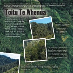
parts of the Waioeka Gorge were Tamatea, ancestor of Ngati Ira. They The Waioeka has been occupied
include T
include Te Karoro a Tamatea (the seagull e Karoro a Tamatea (the seagull
cleared and burnt and replaced by Most of this steep south- include Te Karoro a Tamatea (the seagull by Ngati Ira for hundreds of years. Many
of Tamatea) – a massive white rock 200
pastoral grassland. The farms were facing slope is primary (old of Tamatea) – a massive white rock 200 pa sites have been identifi ed, including a
metres upstream from here which was
metres upstream from here which was
later abandoned and native bush growth) native forest that blasted in an effort to improve water fl ow. number near the entrance to the gorge.
blasted in an effort to improve water fl ow.
has never been cleared.
gradually returned. Secondary The main tree species is It is said the rock was the most inland
It is said the rock was the most inland
point that seagulls would visit. Further
(new growth) native vegetation can tawa. Notice the darker point that seagulls would visit. Further In the 1860s, Ngati Ira settled near
now be recognised by its lighter forest forming narrow downstream we come to Te Heru a here at Maraetai Pa under the
leadership of Hira Te Popo. They
Tamatea (the comb of Tamatea) – a large
colour and finer texture. Primary strips on two spurs Tamatea (the comb of Tamatea) – a large had been attacked by government
rock in the shape of a ladder.
(old growth) forests have a darker (secondary ridges). troops at a number of pa sites
colour and coarser texture. nearer Opotiki. Oponae’s
strategic location provided both
security and an abundant food
supply. They remained here for
fi ve years, emerging in 1870
to settle at Opeke Marae at the
Opotiki entrance to the gorge.
The narrow strips of darker forest are
podocarps (conifers) rimu and miro, In the 20th century local iwi were
believed to have established on steep heavily involved in the construction
spurs burnt about 400 years ago. The and maintenance of the road through
spurs may have been burnt to provide the gorge. Many lived in this area in
access to and visibility from the high Ministry of Works huts, with children
vantage points on the main ridge. The gathering fruit from trees that were
ridge is Te Tii, and commands a clear planted in the 1860s.
view of the valley.
Trees give us clues about whether land was cleared recently or long ago. “Ponae means food basket, Oponae means your food basket. A natural habitat for the tuna, inanga and kereru, Oponae was used as a
The diagonal band of taller trees running through the centre of this photo strategic area, with all its conveniences, security, strategic locality and abundant food source. In the mid 1860s the Crown troops plundered
is mostly rewarewa. It is much older than the new growth broadleaf scrub Opotiki and Ngati Ira bore the brunt of this. Troops devastated and levelled their pa, Te Tarata, on the Waioweka fl ats with the Crown
in the foreground. practicing its scorched earth policy.” HONE KAMETA - Ngati Ira o Waioweka
This place can be found downstream on the other side of the river between two waterfalls. It was used as a sentinel lookout to report It is the largest native plantation I remember to have seen.” COLONEL THOMAS PORTER - Diary 1870
on people moving up and down the river.” HONE KAMETA - Ngati Ira o Waioweka
There are many places associated with e are many places associated with
In the early 20th centur
In the early 20th century, large y, large Ther NGATI IRA
parts of the Waioeka Gorge were
parts of the Waioeka Gorge were Tamatea, ancestor of Ngati Ira. They The Waioeka has been occupied
include T
include Te Karoro a Tamatea (the seagull e Karoro a Tamatea (the seagull
cleared and burnt and replaced by Most of this steep south- include Te Karoro a Tamatea (the seagull by Ngati Ira for hundreds of years. Many
of Tamatea) – a massive white rock 200
pastoral grassland. The farms were facing slope is primary (old of Tamatea) – a massive white rock 200 pa sites have been identifi ed, including a
metres upstream from here which was
metres upstream from here which was
later abandoned and native bush growth) native forest that blasted in an effort to improve water fl ow. number near the entrance to the gorge.
blasted in an effort to improve water fl ow.
has never been cleared.
gradually returned. Secondary The main tree species is It is said the rock was the most inland
It is said the rock was the most inland
point that seagulls would visit. Further
(new growth) native vegetation can tawa. Notice the darker point that seagulls would visit. Further In the 1860s, Ngati Ira settled near
now be recognised by its lighter forest forming narrow downstream we come to Te Heru a here at Maraetai Pa under the
leadership of Hira Te Popo. They
Tamatea (the comb of Tamatea) – a large
colour and finer texture. Primary strips on two spurs Tamatea (the comb of Tamatea) – a large had been attacked by government
rock in the shape of a ladder.
(old growth) forests have a darker (secondary ridges). troops at a number of pa sites
colour and coarser texture. nearer Opotiki. Oponae’s
strategic location provided both
security and an abundant food
supply. They remained here for
fi ve years, emerging in 1870
to settle at Opeke Marae at the
Opotiki entrance to the gorge.
The narrow strips of darker forest are
podocarps (conifers) rimu and miro, In the 20th century local iwi were
believed to have established on steep heavily involved in the construction
spurs burnt about 400 years ago. The and maintenance of the road through
spurs may have been burnt to provide the gorge. Many lived in this area in
access to and visibility from the high Ministry of Works huts, with children
vantage points on the main ridge. The gathering fruit from trees that were
ridge is Te Tii, and commands a clear planted in the 1860s.
view of the valley.
Trees give us clues about whether land was cleared recently or long ago. “Ponae means food basket, Oponae means your food basket. A natural habitat for the tuna, inanga and kereru, Oponae was used as a
The diagonal band of taller trees running through the centre of this photo strategic area, with all its conveniences, security, strategic locality and abundant food source. In the mid 1860s the Crown troops plundered
is mostly rewarewa. It is much older than the new growth broadleaf scrub Opotiki and Ngati Ira bore the brunt of this. Troops devastated and levelled their pa, Te Tarata, on the Waioweka fl ats with the Crown
in the foreground. practicing its scorched earth policy.” HONE KAMETA - Ngati Ira o Waioweka